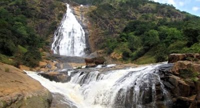
Amazing Pictures: All About FARIN RUWA Waterfalls(Nigeria’s highest waterfall)

NAME: Farin Ruwa
LOCATION: Nassarawa/ Plateau State Nigeria.
KNOWN TO BE A: Waterfall
ABOUT
 |
| www.takemetonaija.com |
Farin Ruwa waterfalls, which was first discovered in the 1950s by the colonialists, is a spectacular waterfall about 120 kilometres away from Lafia, the capital city of Nasarawa State, 30 kilometres away from Wamba, the local government headquarters and about 160 kilometres from Abuja, Nigeria’s federal capital.
The waterfall is geographically situated in Wamba Local Government Area of Nasarawa State – just between the boundary of Bokkos and Wamba local council areas of Plateau and Nasarawa States respectively.
To develop the waterfall to international tourism standards, the Nasarawa state government is investing millions of dollars to build chalets and a hotel complex, a golf course, water and amusement parks, among other recreational facilities that will attract tourists by their thousands.
When completed, they would transform the waterfall into the biggest tourist destination in Nigeria, put Nasarawa State on the world tourism map and transform the country into a major tourist destination.
Farin Ruwa is just as spectacular as Canada’s Niagara Falls and Zambia’s Victoria Falls. The nature and beauty of the waterfalls takes ones’ breath away!
It is a truly magnificent work of nature for its high level falls which is about 150 metres high and 50 metres wide, absolutely incomparable with other waterfalls in Nigeria.
MAP
Farin Ruwa coined it’s name from the local inhabitants within the area due to the nature of the falls. Due to the height covered on the descent as well, the water crashes heavily on its way down the Jos plateau escarpment, gradually turning the water white in color.
From a distance, to inhabitants of Farin Ruwa and tourists alike, a white like smoke covers the mountains.
Found in the Farin Ruwa Development Area, under Wamba Local Government Area of Nasarawa State, the falls shares a boundary with Plateau State.
To protect its rich heritage, the colonial administration gazetted it and named it Marhai Forest Reserve. However, despite this early development, Farin Ruwa was consigned to the background until the creation of Nasarawa State in 1996.
When To Visit Farin Ruwa Waterfalls
 |
| naijatreks.com |
The best
time to visit and see Farin Ruwa at its highpoint is in the month of
April through the summer months of July, August and September. Aided by
the mid-year rains, Farin Ruwa becomes tempestuous, roaring down the
hills in a stream of whiteness.
The force of its
gusting water is so torrential that it can be mistaken for white smoke
or white liquid from where it gets its name – Farin Ruwa, meaning “White
Water” in the Hausa language.
Eco-Tourism At Farin Ruwa Waterfalls
 |
| omgvoice.com |
Farin Ruwa is captivating; tumbling 150 metres, the waterfall is a cascade of three falls 50 metres wide creating a natural spectacle that is at once beautiful and breathtaking.
Its tourism potentials have been noted internationally as the World Tourism Organisation has listed it as a world tourist site. Much of the surrounding environment is light forest, making the area ideal for eco-tourism.
Birdwatching At Farin Ruwa Waterfalls
 |
| naijatreks.com |
The surrounding forest also makes the area a prime location for bird watching and over 2,500 birds from 148 species had been found within the area. Of the 148 bird species, 15 are of conservation importance and three are typical of the forest habitat. The 15 species of conservation importance suggest that the forest reserve within the area is an important bird enclave.
EXCITING PICTURES OF FARIN RUWA WATERFALLS:
| www.takemetonaija.com |
 |
| www.takemetonaija.com |
 |
| omgvoice.com |
 |
| www.takemetonaija.com |
 |
| summitpost.org |
 |
| naijatreks.com |
 |
| naijatreks.com |
 |
| naijatreks |
SOURCES: cometonigeria.com, www.takemetonaija.com, omgvoice.com


