TOURISM: Introduction To The Gashaka Gumti National Park And The Highest Mountain In Nigeria. [Beautiful Pictures.]

Due to some reasons we haven’t been able to visit some fantastic tourists destinations in Nigeria of recent but we are going to resume our tours next year definitely. In the mean time here is an introduction to Nigeria’s National Park the Gashaka Gumti national park a very beautiful park it is also a place where you can also find the highest peak in Nigeria; Chappal Waddi, a mountain 2419
meters tall. Isn’t that great?? Well, T.I.N Magazine definitely plans to make a visit next year to show you are dear readers better pictures and a detailed video recording.
Below you will find all you need to know about the Gashaka Gumti national park and Chappal Waddi.
The images and info below were gathered from different web pages.
eastern Nigeria close to Cameroon border north of Mambilla plateaus. The
park covers 6,731 sq km wilderness, it derives its name from two of the
region’s oldest and most historic settlements: Gashaka village in
Taraba State, and Gumti village in Adamawa State. The park is among the
seven national parks in Nigeria and also the most scenic and biological
diverse conservation enclave; it compasses savannah, forests, wetlands,
andmontane habitats in a continuous ecological transition.
 |
| Gumti monkey |
in a north east direction to faro, Benue and Boubandjida National parks
in Cameroon. The terrain is characterized by steep, thickly forested
slopes, deep plunging valleys, precipitous escarpments and swiftly
flowing rivers. Altitude ranges from 450 meters above sea level in the
wild savannah plains of the Northern sector, to the peaks and pinnacles
of Gangirwal in the Southern park sector, which at a staggering 2,400
meters above sea level, represents Nigeria’s highest mountain.
 |
 |
The park has a variety of different habitats that makes it uniquely
rich in wildlife. In fact it is actually an intricate mosaic of montane
grasslands, savannah woodlands, swamps, lakes, mighty rivers, dark
lowland rainforests, and luxuriant, montane rainforests strewn with
ferns and orchids. Each habitat supports its own distinctive community
of plants and animals.
Gashaka Gumti National park is the home of highest mountain chappal
waddii which is also known as “Mountain of Death” located southern
sector of the park locally called Gangirwal which requires eight to ten
days trek to appreciate it. The park also has Chappal Hendu the
“Mountain of wind”; it also has rivers that flow through it including
River Taraba, River Benue and River Kam which makes the park an
excellent place for fishing.
The fauna in the park includes Lions, mountain reedbuck, roan
antelope, hippopotamus, crocodiles, chimpanzees, baboons, hyenas,
elephants, rhinoceros, African manate, putty nosed guenon, panta
monkeys, aardvark, porcupine, wild dog, Senegal bush baby, grey cheeked
mangabey, tantalus monkey, giant forest hog, warthog, cheetah, buffalo,
waterbuck, bushbuck, kob, bush pig, hartebeest, silky black and white
colobus monkeys, white face mona monkey, civet, genet, golden cat
leopard, red river hog duiker, oribi, klipsringer, yellow- backed
duiker, giant eland etc.
 |
 |
 |
 |
The park also features over 500 bird species, 50 different fish
species, primate watching, and sport fishing. This area is best explored
on foot with accompanied guide. The best time to visit the park is
during December to April because of weather condition then from late
July to November accessibility to park is quite difficult because the
rivers, streams overgrown vegetation and marshy areas has flooded. The
greater part of the park is inaccessible to vehicles due to undulating,
difficult and rugged terrain as well as thick vegetation and
crisscrossing rivers and streams.
The park is officially labeled one of the Africa’s “Important Bird
Areas” it also contains some historic sites which is one of the pre 1918
German fort on top of Gashaka hill which is known as “watch tower” used
by the German military expedition to the area. Some graves of German
soldiers are still found dotted at the fort of the hill.
Although the entire National Park is suitable for tourism there are a
number of areas sufficiently attractive as to merit special attention
– such as the enclaves described above. We shall first consider those
that are within easy reach of Gashaka village, before those further
afield, in the Northern park sector.
CHAPPAL WADDI – HIGHEST PEAK IN NIGERIA.
inhale the jungle and let remote paradise penetrate your soul. A
phenomenally exhilarating climb awaits you from the vast hilly and
rugged terrain crossed by leopards and grazed by buffalo to the
fabulously lush emerald green jungle inhabited by fascinating primates,
Chappal Waddi is truly a feast for your senses.
Gashaka Gumti National Park on the border of Cameroon, Chappal Waddi
(Mountain of Death) is considered the highest peak in Nigeria at 2419
meters. It is largely undiscovered leaving the door open for you to
venture into a world very few, if any, have experienced. Feel the rocky
riverbed under your feet, see the strange and wonderful fish swim
around your legs as you walk the cool flowing rivers. As the Black
& White, Colobus and Putty Nose monkeys peer at you through the big
leaves of this emerald gem and you hear the Red River Hogs and Warthogs
charge through the jungle let the thrill of this wonderful Eden seep
under your skin.
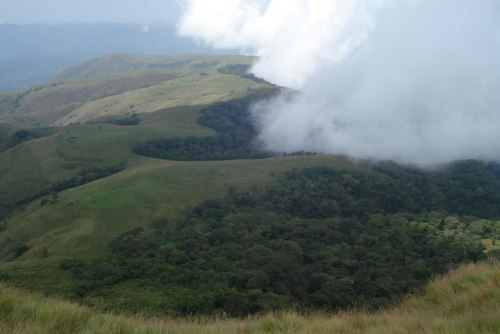 |
| Chappal |
churning in your stomach feels like you just swallowed the brilliantly
multi-coloured butterflies that flit around you on the thick forested
slopes. As you step through this adventure with thrilling trepidation
at what wonderful site you are going to encounter next you explore
further into a vast fantasy come to life. Mischievous chimps, gushing
waterfalls, crystal pools, paradise is attainable it’s just the world’s
best kept secret.
MORE ABOUT THE NATIONAL PARK
The Bat Forest
 |
| bat forest |
The bat forest, or Kurmin Jemage, so-called because of the large
numbers of fruit bats that roost in this eerie and mysterious forest
at certain times of the year, can easily be visited from Gashaka
village as a day-trip. A variety of other ungulates and primates can
also be seen here, including forest animals and animals of the
surrounding savannah woodlands.
The Hot Springs
Near to Gashaka village there are hot springs close to Mayo Jiagum
and on the Southern park boundary there are hot springs at Matashirip
also.
The German Fort
The ruins of the pre-1918 German fort situated on a small hill
overlooking Gashaka village are of historical importance, as are the
ruins of the German administrative centre near Garbabi village on the
road to Beli.
The Hippo Pool
 |
| Hippo Pool |
Each dry season the “Hippo Pool” located only a few kilometres
upstream of the River Kam bridge provides an ideal opportunity for
tourists and researchers alike to study the habits of the
hippopotamus at close quarters. These hippos are quite accustomed to
such visits, remaining calm and undisturbed throughout.
Although it is quite safe to watch hippos from the bank as they bask
peacefully in the water they should be avoided if ever encountered on
land. Hippos are unpredictable, and not only with one another, they
can suddenly become very aggressive if an intruder gets between them
and the water. On land they may look clumsy but they are amazingly
agile for their bulk and in an emergency can gallop at speeds up to
30 kilometres per hour.
The Forests at Kwano
 |
| kwano |
The old abandoned village site of Kwano is an excellent location from
which to explore rainforests on the lower slopes of Chappal Tale and
beyond. Since the year 2000, a field station for researchers has been
erected at this site. The forests here represent some of the best
locations for primate watching anywhere in the park. Kwano moreover
is easily accessible: a well-worn footpath leads the 13 kilometres
from Gashaka village to Kwano (3 hours), passing through savannah
woodland and interesting strips of gallery forest. During the dry
season, the path can often be navigated by vehicles.
Daneji
Daneji is a remote wilderness are on the Cameroon border, best
approached from Toungo through the boundary village of Mayo Butale.
From Daneji one can either follow the River Daneji itself down to the
junction with the River Yim and return to Toungo via Jiman and Kila
(a round trip of 6-8 days from Toungo), or else continue further on
into the mountains of Lenga.
The Lakes Around Tipsan
Each dry season large concentrations of animals congregate around
several small lakes located in the vicinity of Tipsan. Tipsan is
easily accessible from Toungo.
The Mountains of Tepel and Lenga
 |
| Tepel and Lenga |
Close to the border with Cameroon, these mountains probably represent
the most remote and inaccessible wilderness region of the entire
park. Little known and rarely visited except by lion and buffalo,
this is the ultimate expedition for the truly adventurous. Best
approached from either Daneji or from Gumti village via the River
Yim. Frome here, visitors can trek into the Gashaka sector via
Filinga enclave, of, alternatively, return down the River Yim to
Gashaka via the Sukare valley. Gumti is best approached either from
Toungo of by following the Karamti to Tapare to Adagoro (9 hours).
Gangirwal Mountain
Gangirwal or Chappal Waddi, at 7,936 feet above sea level (2,419
metres) is the highest mountain in Nigeria. Located within the Gotel
Mountains in the extreme South-eastern corner of the National Park
the summit itself is bisected by the international border with
Cameroon. This mountain is a truly wondrous place that has the power
to uplift the spirit and delight even the most hardened of
travellers.
The upper surface of the mountain carries a flora unique to Nigeria.
Most of it is covered with montane grassland and is grazed by cattle
from Cameroon. Locally, streams are fringed with narrow strips of
montane scrub and a few small patches of forest. The precipitous
faces and slopes of the mountain are covered with luxurious montane
forest, forests which are known to contain a number of rare trees,
butterflies, birds, amphibians, and small mammals. Such forests are
found nowhere else in Nigeria.
The mountain can be reached most easily by driving from Serti to the
town of Njawai on the North-east corner of the Mambilla plateau (6
hours). This road is difficult and a 4WD vehicle is recommended. From
this altitude the ascent of the mountain is relatively easy without
much steep climbing involved at all. Continuing to the summit on foot
from Njawai the journey is best divided into 2 stages. From Njawai to
the small friendly village of Jauro Hammasaleh is a 6 hour walk, from
where, refreshed after a good nights sleep, the summit of the
mountain can be reached in a further 5 hours walk. For the truly
adventurous the mountain can be approached through the park itself,
trekking from Gashaka village via Sabere enclave (a round-trip of
8-10 days).
Horse Riding
Certain areas of the park are suitable for horse riding including the
Hendu-Shirgu Mountains. Horses and guides can be hired for both of
these areas at Selbe and Njawai respectively.
Sport Fishing
 |
| Fishing |
The park’s numerous, beautiful rivers are well stocked with fish,
including the mighty Nile perch and the spectacular Tiger fish. At
times, park authorities might allow catching these fish to then
release them again (“sport fishing”). The main season for this
activity is during the dry season when the rivers are clear and free
from any silt load. The most widely used and successful methods of
fishing include “spinning” with the use of artificial lures or
spoons, although fly fishing has also been used to effect. .
Some of the fish species likely to be encountered include Tiger fish
(Hydrocynus vittatus), Nile perch (Lates
niloticus), Large-scaled characin (Brycinus
macrolepidotus), Golden barb (Babrus bynni), Catfish
(Babrus docmac), Shovel-nosed catfish (Auchenoglanis
occidentalis), Sucker fish (Labeo coubie), Electric
catfish (Malapterurus electricus)
One of the most common fishes of the park is the catfish, which
despite their ugly appearance are among the most highly prized of all
food fish in West Africa. Catfish have broad, flattened heads and
wide mouths which bear well-developed barbels or “whiskers” from
where they have acquired their popular name. They eat almost anything
found in a river: fish, mud, rotten vegetation and insects. Catfish
possess special accessory breathing organs which not only allow
catfish to live in stagnant ponds but also to travel over damp ground
in their migrations to new pools.
 |
| fishing |
The largest fish in the park is undoubtedly the enormous Nile perch,
with specimens 2 metres long and weighing 80 kilograms or more not
unknown. Locally they are known as “giwan ruwa” or the elephant
of the water. The most unusual fish of the park is the electric fish,
capable of delivering an electric shock to anything foolish enough to
stray within its reach. Primarily a defence mechanism rather than one
of attack, the electricity generated is not sufficiently strong
enough to be dangerous to man, although it is rather unpleasant. All
kinds of magical properties are attributed to this fish by local
people.
In total more than fifty different species of fish have been recorded
from the park including the recent discovery of two species entirely
new to science from the genera Bryconaethiops and
Gobiocichla.
LIKE WE SAID EARLIER, T.I.N MAGAZINE PLANS TO MAKE AN OFFICIAL VISIT TO THIS WONDERFUL PARK NEXT YEAR.. STAY TUNED!
SOURCES: www.ucl.ac.uk,nigeria-direct.com,logbaby.com